
| |
| |||||||
| GPS Aca encontraras todo lo relacionado con Sistema de posicionamiento global (GPS) mapas, programas y demas |
| Hola Invitado! Tómate un minuto para registrarte, es 100% GRATIS y no verás ninguna publicidad! ¿Qué estás esperando? | Registrarse Ahora |
 Rutas y Mapas de Colombia y E.U. Enero 2010 para GPS garmin totalmente grastisParticipa en el tema Rutas y Mapas de Colombia y E.U. Enero 2010 para GPS garmin totalmente grastis en el foro GPS. |
| | ||||
| Tema | Autor | Foro | Respuestas | Último mensaje |
| Mapas GPS Colombia ruteado para Garmin | himmelstern | GPS | 23 | 19-03-2012 02:04:00 |
| Se anuncia que Metallica estaría en Colombia en enero de 2010 ! | enzomatrix | Rock | 10 | 12-11-2010 22:53:42 |
| Soho enero 2010 | Wehrmacht | Television y Farandula | 3 | 23-12-2009 18:51:09 |
| En Semana Santa, 43 rutas Vive Colombia, Viaja por Ella | !!! OoOops !!! | Politica y Sociedad | 8 | 12-04-2009 21:23:39 |
| Garmin zümo 660 / GPS para motos | !!! OoOops !!! | Tuning / Autos / Motos | 2 | 10-04-2009 15:32:59 |
 |
| | #81 | |
| Denunciante Nuevo |
podemos ayudar un poco pero el reto es pamacol 8.8 si consigues ese lo posteas y te enviamos la solucion de gisc0
| |
| |
| |
Twittear Seguir a @denunciando
|
| | #1.5 | |||||||||||||||
| SponSor  |
| |||||||||||||||
| | ||||||||||||||||
| | #82 | ||
| Denunciante Popular | Cita:
 El FID es 12450, y pues el garmin unlocker solo te da un codigo de desbloqueo de 4 digitos, y no he podido modificarle el FID como yo quiera para que el garmin unlocker lo pueda trabajar. no se si haya una versión de garmin unlocker más reciente, o como modificarle el FID a ese mapa al numero que yo quiero, a mi me toco subirlo como en los videos al mapsoure, y de ahi enviarlo al GPS a mi me dice FID maps don't match. Error, el mapa se deja intacto, lo otro sería quitarle el codigo del desbloqueo con el mpasource Última edición por himmelstern; 10-04-2010 a las 09:52:44 | ||
| |
| | #83 | |
| Denunciante Nuevo | Cita:
ok dame el id de tu unidad y te enviare el archivo .nul para que lo trabajes en tu gps pero no descansemos hasta encontrar el pamacol 8.8 | |
| |
| | #84 |
| Denunciante Nuevo |
obsequiare solo 2 licencias para esta vercion ... cuando obtenga el 8.8 pamacol de alguno de ustedes de seguro obsequiare otro par |
| |
| | #85 | ||
| Denunciante Nuevo | Cita:
anda dale enviame el id de tu gps te enviare el archivo .nul para que lo utilizes | ||
| |
| | #86 |
| Denunciante Popular |
yo he podido utilizar todas sin el archivo.nul
|
| |
| | #87 |
| Denunciante Nuevo |
te quiero ayudar con ese que ahun no es psible modificarlo pero si cres que puedes acerlo a tus ordenes
|
| |
| | #88 | |
| Recien Registrado |
Saludos Por ahora la mas reciente que tengo es esta.... Pam@col 8.2 bloqueada
Le agradeceria a quien me regale el link de una version mas reciente. | |
| |
| | #89 | |
| Denunciante Popular |
This topic just for reference. I advise to use the "create_mapsource_installationfiles_with_mkgmap.bat" or "create_mapsource_installationfiles.bat" instead. The principle of gmaptool when using the GUI version (gmaptool.exe) is very easy. First you select all *img that you want to integrate into your new mapset in Explorer/Commander and drag it into the main Window. Then you select an operation at the top. To use it you have to know some Vocabs first however. I won't explain computer basics here. They are needed to use gmaptool. It's not clickibunti. I will explain the easiest way to use it here, there are many other ways to achieve the goal with gmaptool – as gmaptool is very powerful. Vocabs Overview Image: Usually named mapset00.img. Needed to show maps in Mapsource. Can be generated by maptk or cgpsmapper. Same as Preview Map. Preview Map: Same as overview image. Different Term for the same thing. TDB File: The File that holds the information which *img belong to the mapset Mapset: An assortment of map tiles (*.img) that is joined together by .tdb, overview image (mapset00.img), and .mdx. An example is openmtbmap_at, while openmtbmap_de would be another mapset. FID – Familiy ID. This is a number between 100 and 9999 (please don't use any other values, while in principle they do work, they might bring forward problems). Every Mapset needs an unique ID. You should use Mapsettoolkit to check for the FID of other maps installed to your computer so that you don't choose a FID that has been taken already. PID – Product ID: Allways set to "1" TYPFile: File that holds the information about how map objects are displayed. Can be changed to please different tastes. Ends with .typ. Openmtbmap.org maps need a typfile. Some maps like City Navigator also look o.k. without typfile. Prerequisites Get maptk and enter the path to it on the options tab. You could also use cgpsmapper, but maptk usually works better (isn't that the reason why you use gmaptool instead of mapset toolkit in first place?). Enable "Advanced Options" in the options tab too. You don't need experimental options (if you read this guide, you obviously don't want to enable them). Generating a preview map and install.bat to install maps to Mapsource: 1. Drag and Drop all *img you want to include into gmaptool main window. Also drop in the TYPFile. Watch out to not include the overwiew image. If you want to integrate contourlines, you want to drag them as well as the openmtbmap.org maps into here. If you want to you can combine maps of several countries. Note that this will not enable Autorouting over boarders, but it will enable you to see the maps at the same time in Mapsource without needing to change the mapset. 2. Click the tab "Split" and choose an directory which is empty to which gmaptool can send the maps. 3. Select in the drop down menu: Create Files for Mapsource 4. Check "Compile Preview Map". 5. Set Mapset FID to a value not used (use mapsettoolkit to check), set PID to 1. 6. Select Add empty DEM if you wan't to be able to display the maps with Basecamp. (experimental option?) 7. Click on "Split all" . and let gmaptool do the work – You don't want to check any of the following but leave them empty: "Limit Preview Map", "Limit Mapset Area", "Set Code Page" or "Create TDB v3 when possible". If in doubt click on "?" to see gmaptool help. — Now you can go to the folder you specified and run install.bat. Remeber again, it needs admin rights. If the colors are wrong, then this means your typfile was not included. This is the case if the fid/pid of the typfile are not the same as the ones of the maps. In that case use mapsettoolkit to add the typfile to the maps (and change the FID/PID of the typfile automatically after confirmation). Additional notes for SRTM Contourlines Installation: I recommend to keep to seperate folders. One for the standard openmtbmap_austria installation, and a second one for the srtm files (plus the current openmtbmap_austria tiles). So unzip the srtm files to any folder you like, copy (don't move) the openmtbmap_austria map tiles (all files ending with ".img" and having a 8 digit filename (i.e. 63660001.img, but not mapset00.img!) also in that folder. Also copy the mtbat.TYP file into the folder. However you have to rename it, so there is no conflict in your GPS (Mapsource will tolerate you not renaming it – but the maps may display wrong) be carefull, maximum 8 characters are allowed. I named it srtmat.TYP Then follow the above guide. You will have to set a mapID – I would recommend using 6365 if it is not yet used (openmtbmap_italy uses 6367), but you may use any other number from 100-9999. Don't use 6366 as this the number the openmtbmap_austria uses. After clikcing on "START" you will get a notice saying that the FID and PID of the .TYP File are wrong and you will be asked if it should be changed. Click Yes on that question. Then you have can send the maps either with or without contourlines to your GPS (or send both versions, and then upon use enable the one you want using the map setup window of your GPS. Please Note: the *.img files containing the contourlines must be named higher than the maps containing the background polygon. Otherwise the will not show in Mapsource if you include them into the same .tdb. This was wrong in the SRTM Contourlines offered for Austria (update available as of 10.08.2009). Simply rename those tiles from 6224 to 7224 and redo the installation (either with mapsettoolkit or gmaptool –> which I do prefer by now for map installation) or download the srtm files again. Updating the Maps Updating your standard openmtbmap installations is as easy as overwriting the old files. For installs of maps including the SRTM contourlines this is a bit more difficult. In case the number/naming of tiles changes, you need to delete the old *.tdb and the old mapset00.img (generated by cgpsmapper) in your SRTM installation folder, then overwrite the old tiles (*.img) with the newer ones and follow the above installation again. You will also have to do this when after updating the maps – on sending the maps to the GPS with Mapsource, Mapsource complains about an error (usually somethin like there are only 1000MB of free space on your GPS, you try to send 200MB of maps – notice that the second number is smaller – this indicates that the mapset00.img is not working for your maps and needs to be regenerated). | |
| |
| | #90 | ||||
| Denunciante Popular |
recommend using Gmaptool or the script "create_mapsource_installationfiles" / create_mapsource_installationfiles_with_mkgmap". For me mapsettoolkit usually worked fine, alternatively use this:
Sometimes the map will not install correctly, then you could follow this guide. (Note in case of problems first read the FAQ). 1. Download and Install Mapsettoolkit 1.75beta or later:
2. Download and Install maptk:
4. Install the maps: a) "Select IMG" select all map images (.img): (choose the folder you extracted the maps to). Then click on "Select All" and on the right side click "Add". Now the mapnames should show up on the right and lift window 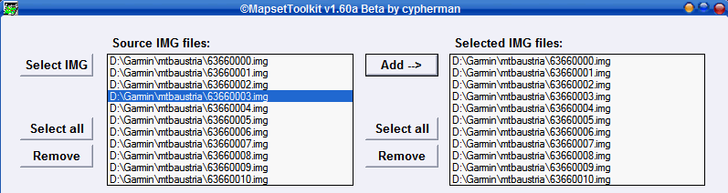 b) "Select mapset directory" (this should be the directory to which you extracted the maps, but you can choose any directory). c) "Mapset Name" give the mapset a name this name will show in Mapsource to select the map i.e. openmtbmap_at d) "Family ID" set any number between 100 and 9999. It should not be used already (check looking through the "FID" field on the right of the main window) i.e. 6366 e) Select .TYP file. 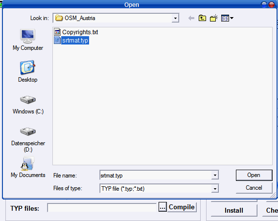 f) Tick both options "Install in mapsource" and "blank Overview maps" 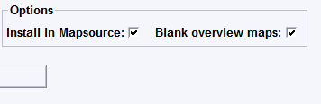 g) Controll Everything then Click on "Start" 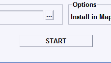 Here is the full view before clicking on start. Note there might be a warning shown, or error, but using cgpsmapper 097 it should nevertheless install correctly. 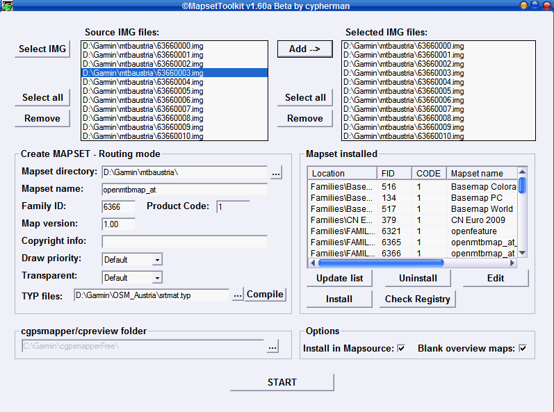 Additional notes for SRTM Contourlines Installation: I recommend to keep to seperate folders. One for the standard openmtbmap_austria installation, and a second one for the srtm files (plus the current openmtbmap_austria tiles). So unzip the srtm files to any folder you like, copy (don't move) the openmtbmap_austria map tiles (all files ending with ".img" and having a 8 digit filename (i.e. 63660001.img, but not mapset00.img!) also in that folder. Also copy the mtbat.TYP file into the folder. However you have to rename it, so there is no conflict in your GPS (Mapsource will tolerate you not renaming it but the maps may display wrong) be carefull, maximum 8 characters are allowed. I named it srtmat.TYP Then follow the above guide. You will have to set a mapID I would recommend using 6365 if it is not yet used (openmtbmap_italy uses 6367), but you may use any other number from 100-9999. Don't use 6366 as this the number the openmtbmap_austria uses. After clikcing on "START" you will get a notice saying that the FID and PID of the .TYP File are wrong and you will be asked if it should be changed. Click Yes on that question. Then you have can send the maps either with or without contourlines to your GPS (or send both versions, and then upon use enable the one you want using the map setup window of your GPS. Please Note: the *.img files containing the contourlines must be named higher than the maps containing the background polygon. Otherwise the will not show in Mapsource if you include them into the same .tdb. This was wrong in the SRTM Contourlines offered for Austria (update available as of 10.08.2009). Simply rename those tiles from 6224 to 7224 and redo the installation (either with mapsettoolkit or gmaptool > which I do prefer by now for map installation) or download the srtm files again. Updating the Maps Updating your standard openmtbmap installations is as easy as overwriting the old files. For installs of maps including the SRTM contourlines this is a bit more difficult. In case the number/naming of tiles changes, you need to delete the old *.tdb and the old mapset00.img (generated by cgpsmapper) in your SRTM installation folder, then overwrite the old tiles (*.img) with the newer ones and follow the above installation again. You will also have to do this when after updating the maps on sending the maps to the GPS with Mapsource, Mapsource complains about an error (usually somethin like there are only 1000MB of free space on your GPS, you try to send 200MB of maps notice that the second number is smaller this indicates that the mapset00.img is not working for your maps and needs to be regenerated). | ||||
| |
|

| Etiquetas |
| 2010, colombia, enero, garmin, gps, grastis, mapas, rutas, totalmente |
| |
 2Me Gusta